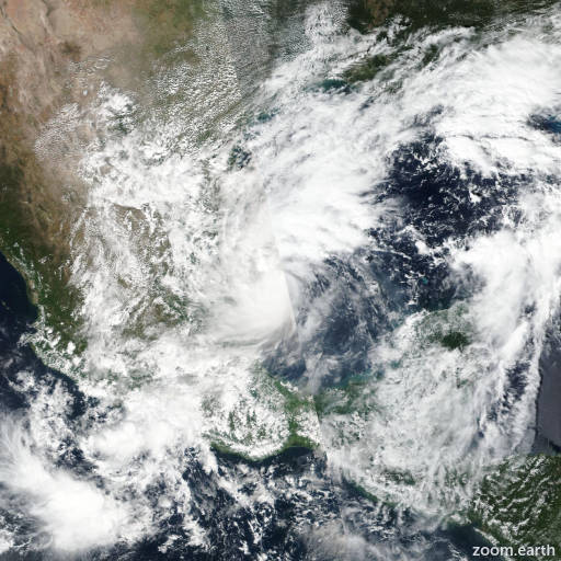
Hurricane Milton 2024
Last Modified:

Live tracking map, satellite images and forecasts of Hurricane Milton 2024 in the Gulf of Mexico. Current wind speed 80mph. Max 125mph.
Milton is forecast to quickly intensify while it moves eastward to northeastward across the Gulf of Mexico and be a major hurricane when it reaches the west coast of the Florida Peninsula mid week. Users are reminded to not focus on the details of the forecast as there remains significant uncertainty in the eventual track and intensity of Milton.
While it is too soon to specify the exact magnitude and location of the greatest impacts, there is an increasing risk of life-threatening storm surge and damaging winds for portions of the west coast of the Florida Peninsula beginning Tuesday night or early Wednesday. Storm Surge and Hurricane Watches could be issued later today (6 October) or tonight. Residents in the Florida Peninsula should follow any advice given by local officials and check back for updates to the forecast.
Areas of heavy rainfall will impact portions of Florida today and Monday well ahead of Milton, with heavy rainfall more directly related to the system expected later on Tuesday through Wednesday night. This rainfall will bring the risk of flash, urban, and areal flooding, along with the potential of moderate to major river flooding.
Tropical storm conditions are expected beginning Monday across portions of the northern Yucatán Peninsula of Mexico where a Tropical Storm Warning is in effect.
Satellite and aircraft data indicate that Milton is strengthening. A large burst of convection is occurring in the northern semicircle of the storm, with lots of expanding outflow. The last fix from the NOAA Hurricane Hunter aircraft showed a pressure down to 991 mb with maximum 500m low-level winds of about 75 mph (65 knots). These winds reduce down to the surface to about 65 mph (55 knots), and this value will be the initial intensity.
The fixes from the aircraft indicate that Milton is south of the previously anticipated and has been moving east-southeastward or 105/5 knots. Milton is forecast to move a little south of due east today in westerly flow from a shortwave trough over the northern Gulf of Mexico. The storm should then turn northeastward and accelerate on Tuesday and Wednesday toward the Florida Peninsula. As a result of this re-positioning and initial motion, there's been a southward change to most of the guidance this morning (6 October). The new NHC forecast is adjusted south of the previous one, especially early on, and further southward adjustments could be required if the guidance trend continues. The Mexican government has issued a Tropical Storm Warning for the north coast of the Yucatán Peninsula as a result of the forecast change. It should be noted that the average NHC track error at day 3 is around 100 miles, and users should not focus on the exact track.
The NOAA Hurricane Hunter crew reported that an eyewall has formed on the last center fix, suggesting that this system is ready to intensify quickly. Given the track over the very deep warm waters of the Gulf of Mexico and little shear for the next couple of days, rapid intensification is explicitly forecast, and the new NHC prediction could still be conservative over the central Gulf of Mexico. The biggest question actually seems to be the intensity as Milton approaches Florida, with much of the guidance showing a notable increase in shear. While some weakening is anticipated, the shear could help transition Milton to be a large hurricane at landfall, with impacts spread out over a big area. Regardless of the details, there is increasing confidence that a powerful hurricane with life-threatening hazards will be affecting portions of the Florida west coast around the middle of this week. Residents there should closely monitor this system and listen to local officials.