Measure Distance

Measure Area

Click on the map to add points. Double‑click to finish.

Tap on the map to add points.

Severe Tropical Cyclone Zelia 2025

Last Modified:
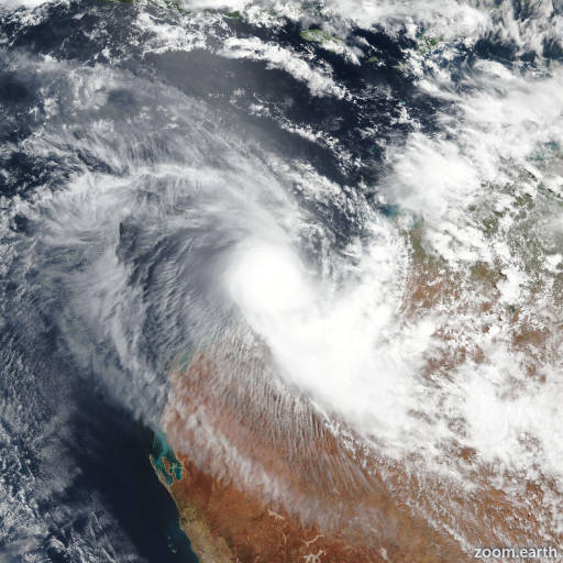
Severe Cyclone Zelia

Live tracking map, satellite images and forecasts of Severe Tropical Cyclone Zelia 2025 near Port Hedland, Australia. Current wind speed 230km/h. Max 260km/h.

Zelia is located 139 km north-northwest of Port Hedland, Australia, and has tracked southward at 2 km/h (1 knot) over the past 6 hours. Maximum significant wave height is 13.7 meters (45 feet).

Zelia is forecast to continue drifting slowly over the next 12 hours, though a slowly strengthening steering gradient on the east side should push it generally towards the south-southwest.

A building subtropical ridge moving west of Papua New Guinea over the next 24 to 36 hours will strengthen gradient on the east side of Zelia, and the system will start moving southward at a slightly greater pace after 12 hours. Landfall along the northwest coast of Australia, between Port Hedland and Dampier, is expected in around 36 hours. Thereafter the system will continue tracking inland over Western Australia along the southwestern side of a north-south oriented ridge over central Australia.

In terms of intensity, the ongoing eyewall replacement cycle will result in a general weakening of the system in the near-term. It is challenging to predict the length of the eyewall replacement cycle but more than likely it will be rather quick due to very small size of the inner-core of Zelia.

Otherwise, conditions remain favorable, and once the eyewall replacement cycle is wrapped up, the system is expected to quickly reintensify. The current forecast calls for a reintensification to 260 km/h (140 knots) in 24 hours, though the actual peak could be slightly higher and occur in 24 to 36 hours, as the system passes over a pool over extremely warm sea surface temperatures and with high ocean heat content and taps into even stronger poleward outflow channel.

Deep-layer shear is predicted to increase sharply right as the system approaches the coast, which will weaken it slightly as it crosses shore, but it will remain an extremely strong and dangerous TC.

Rapid weakening over the deserts of Western Australia will occur after landfall, with the system dissipating in 3 days. Deterministic track guidance is roughly constrained in an envelope from Dampier to the west to Port Hedland to the east, with the majority of the reliable guidance focused tightly near the multi-model consensus mean.

Ensemble guidance is a bit more mixed, with the eceps in particular showing a much wider spread in potential outcomes, with several members taking the system west to about 113E, then turning south and running over Learmonth and Exmouth, while the other extreme members turn the system eastward up towards Broome.

The bulk of the eceps members lie between a midpoint between Dampier and Learmonth and Port Hedland. The GEFS on the other hand is much more constrained, with all members consistent with the deterministic envelope, between roughly Dampier and Port Hedland.

The JTWC forecast lies close to the consensus mean and consistent with the previous forecast but due to the weak steering environment and continued ensemble uncertainty, it is set with medium confidence.

Intensity guidance is for the most part consistent in showing a flat trend for the first 6 to 12 hours, followed by reintensification between 24 and 36 hours.

The JTWC forecast is consistent with the HAFS-A trend with medium confidence.