Measure Distance

Measure Area

Click on the map to add points. Double‑click to finish.

Tap on the map to add points.

Typhoon Wipha 2025

Last Modified:

Typhoon Wipha

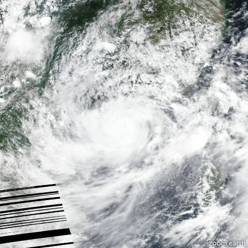
Live tracking map, satellite images and forecasts of Typhoon Wipha 2025 (台風6号) near Macao. Current wind speed 120km/h. Max 130km/h.

Wipha (Philippine name Crising) is located 89 km south-southeast of Hong Kong, and has tracked westward at 24 km/h (13 knots) over the past 6 hours. Maximum significant wave height is 8.8 meters (29 feet).

Wipha is, as previously forecast, now tracking due west along the southwestern side of an extension of the subtropical ridge to the northeast.

The system is expected to make landfall in the vicinity of Yangjiang, China within the next 12 hours, then turn southwestward, skirting the coastline of southern China.

The system will pass in close proximity to Zhanjiang and be moving back over open waters of the far northeastern Gulf of Tonkin in 24 hours. The forward speed of Wipha is forecast to begin decelerating after landfall, due to frictional effects as it interacts with the terrain.

After 24 hours, the weakening of the ridge to the north due to passage of an upper-level trough, will result in a weaker steering gradient and more significant slowdown as the system moves into the Gulf of Tonkin.

The slowdown will only last about 24 hours. However, as another strong ridge over the tibetan plateau builds in from the west and strengthens the steering gradient, Wipha will once again pick up speed after 2 days as it approaches a second landfall over the red river delta southeast of Hanoi, Vietnam.

In terms of intensity, the system has clearly capitalized on the shallow warm waters along the Chinese coast and successfully countered the moderate shear.

Wipha is likely to intensify a bit further prior to landfall, though the proximity to the coastline will likely serve to temper the intensification somewhat as it gets closer to the coast.

The forecast currently calls for a peak of 130 km/h (70 knots) as the system hits the coast, but it is possible it could reach a slightly higher peak if the convection all remains offshore for a bit longer.

As it skirts the coast, the system will weaken significantly due to frictional effects and is forecast to still be a strong tropical storm when it moves back over the Gulf of Tonkin.

Once over water again, the system is forecast to reintensify rather quickly, up to 110–120 km/h (60–65 knots) as it moves across very warm (30–31°C) waters and maintains a relatively favorable upper-level environment of moderate shear and good equatorward outflow.

Once ashore in Vietnam, the system will rapidly weaken and ultimately dissipate over the mountains of northern Laos in 4 days. Deterministic track guidance is in good agreement through most of the forecast period, with minimal cross- or along-track uncertainty through the early portion of the forecast.

Cross-track uncertainty remains fairly consistent through the mid- and extended-range forecast, but along-track spread begins to appear as early as the next 36 hours, when the GFS-GEFS combination starts to diverge from the remainder of the models.

The GFS models show a landfall in Vietnam as early as the next 2 days, while the remainder of the package arrives about 12 to 18 hours later.

After landfall, the ECMWF-ECEPS-ecaifs combination rejoins the GFS before the models disperse as the system weakens and vortex is lost. The JTWC forecast remains consistent with the previous track and the ECMWF tracker through the forecast period, with high confidence.

Intensity guidance is mixed. Only the Decay-SHIPS (GFS) shows any sort of near-term intensification, while the HAFS-A and consensus mean show steady but relatively slow weakening over the next 24 hours.

Conversely, the GFS and HWRF show rapid weakening to just 75 km/h (40 knots) in 12 hours, followed by rapid intensification immediately after. Most of the models show some degree of reintensification in the Gulf of Tonkin, though there is a significant amount of uncertainty in the actual peak.

The JTWC forecast is positioned about 20 km/h (10 knots) higher than the consensus mean through the forecast period.

The extent to which the system penetrates inland in the short term will have a significant impact on the ultimate intensity and thus the confidence in the intensity forecast is medium to low.