Typhoon Ragasa (Nando) 2025
Last Modified:
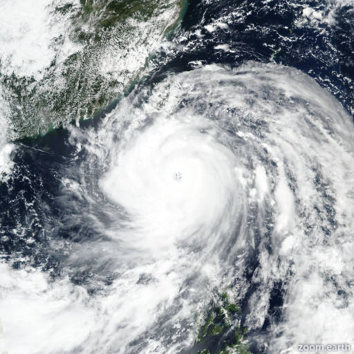
Live tracking map, satellite images and forecasts of Typhoon Ragasa 2025 (台風18号) in the Philippine Sea. Current wind speed 185km/h. Max 250km/h.
Ragasa (Philippine name Nando) is located 872 km east-northeast of Manila, Philippines, and has tracked northwestward at 11 km/h (6 knots) over the past 6 hours. Maximum significant wave height is 8.2 meters (27 feet).
Ragasa will gradually curve to a west-northwestward track along the southern edge of a subtropical ridge to the north over the next 3 days.
After 3 days, Ragasa will curve west-southwestward through the end of the forecast period as a subtropical ridge builds to the north over southwestern China.
The environment will allow for significant intensification to continue for the next 2 days while in a favorable environment of low wind shear and enhanced upper-level divergence.
Above-average ocean heat content east of Luzon will also provide thermal support to rapid intensification, allowing for a peak intensity of 250 km/h (135 knots) within the next 36 hours.
After 2 days, Neoguri will begin weakening as the upper-level environment becomes less favorable. As the system approaches the coast of Hong Kong, Macao, China, and Vietnam, upwelling will further weakening as the system passes into the shallow Gulf of Tonkin.
Deterministic model guidance is in good agreement that Ragasa will move west-northwestward over the next 2 days, then curve southwestward in 2 to 3 days.
Rapid intensification aids continue to trigger within the JTWC SHIPS guidance well above the mesoscale and global model solutions, which seem somewhat out to lunch.
Somehow, HWRF, GFS, and COAMPS-TC have suddenly calculated a swift weakening within the first 12 to 24 hours which is not realistic to the current environment. Thus, the JTWC guidance remains above consensus closer to the rapid intensification aids.