Measure Distance

Measure Area

Click on the map to add points. Double‑click to finish.

Tap on the map to add points.

Typhoon Krathon (Julian) 2024

Last Modified:
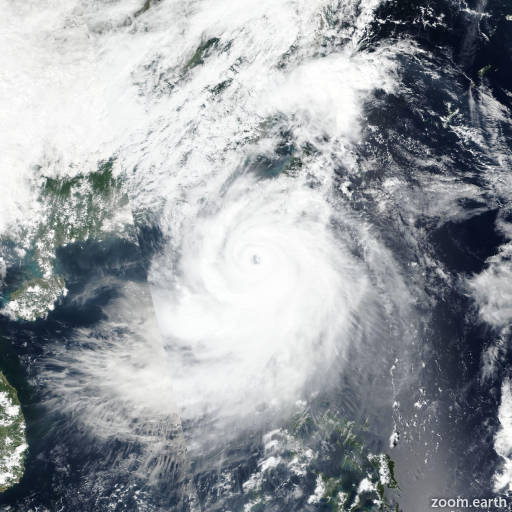
Live tracking map, satellite images and forecasts of Typhoon Krathon 2024 (台風18号) northeast of Luzon in the Philippines. Current wind speed 150km/h. Max 215km/h.

Krathon (Philippine name Julian) is located 904 km south-southwest of Kadena Air Base, and has tracked northwestward at 11 km/h (6 knots) over the past 6 hours. Maximum significant wave height is 8.2 meters (27 feet).

The system is expected to continue strengthening at rapid intensification (RI) levels throughout the duration of its expected track slowly northwestward, passing through the Luzon Strait over excessively warm sea surface temperatures and favorable wind shear values of 10–20 km/h (5–10 knots).

The high ocean heat content values across the Luzon Strait alleviate concern of a depletion of warm water fueling the intensification. The period of strengthening will level off in 2 days due to increasing land interaction Taiwan.

The expected track will curve sharply to the northeast and take the core of the system across the southern (hengchun) peninsula of Taiwan. A quick decay in Krathon’s strength will occur in around 3 days and after.

The wind field, which is already extensive for this system, will gradually expand with the onset of intensity decline. Krathon will begin to accelerate northeastward through the East China Sea as the subtropical ridge to the east latches on as the dominant steering influence driver.

Model guidance is largely predicting a nearly right-angle turn south of Taiwan with some of the less reliable models pulling the consensus too far west at this pivot point.

There is good agreement with a northeastward track following a possible landfall in southern Taiwan in around 60 hours. The uncertainty regarding landfall introduces a greater chance for track errors after 3 days and is reflected in the poor agreement in individual trackers run-to-run and their overall consensus.

Intensity guidance is supportive of the immediate rapid intensification period. Development begins to level off in 2 days, when the numerical models begin to account for the land interaction near Taiwan.

Intensity guidance is in good agreement with the timing and rate of decline over the next 5 days.

Uncertainties in the forecast are due to the initial intensity uncertainties stemming from lack of data and also due to the unknown extent of land interaction with Taiwan.