Measure Distance

Measure Area

Click on the map to add points. Double‑click to finish.

Tap on the map to add points.

Typhoon Fung-wong (Uwan) 2025

Last Modified:
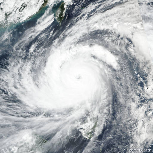
Typhoon Fung-wong (Uwan)

Live tracking map, satellite, radar, and forecasts of Typhoon Fung-wong 2025 (台風26号) in the Philippine Sea. Current wind speed 130km/h. Max 215km/h.

Fung-wong is located 467 km north-northwest of Kayangel, and has tracked west-northwestward at 26 km/h (14 knots) over the past 6 hours. Maximum significant wave height is 9.1 meters (30 feet).

Fung-wong will remain between a competing steering two subtropical ridges to the northeast and northwest for the next 2 days, driving the system along a west-northwestward track. Afterwards, the northwestern ridge will weaken, allowing Fung-wong to curve along the northwestern ridge over the next 3 to 4 days, ending on northeastward track in 5 days.

The environment will remain highly favorable for development for the next 36 hours while the system remains over water in warm sea surface temperatures, low wind shear, and expansive upper-level diffluence.

Weakening will occur after Fung-wong makes landfall at 2 days on Luzon due to topographic interaction with the Cordillera Central mountain range.

Weakening will continue after Fung-wong passes into the South China Sea due to high wind shear above 45 km/h (25 knots) as the typhoon track upstream into the climatological cold surge, ingesting subsident dry air into the circulation.

Weakening will continue at 5 days when the final position is over mainland Taiwan. Deterministic model guidance is in good agreement and consistent in the cross-track guidance, but has a 420 along-track spread at 5 days between GFS (slowest) and GALWEM (fastest).

The spread starts at 3 days once Fung-wong begins to curve around the subtropical ridge. The intensity guidance gives a strong rapid intensification signal despite the large size of the typhoon with the JTWC SHIPS guidance indicating rapid intensification, HAFS-A, HWRF, and COAMPS-TC indicating rapid intensification.

The spread of peak intensities lies at 36 hours from 150–230 km/h (80–125 knots).