Measure Distance

Measure Area

Click on the map to add points. Double‑click to finish.

Tap on the map to add points.

Tropical Storm Danas (Bising) 2025

Last Modified:

Tropical Storm Danas (Bising)

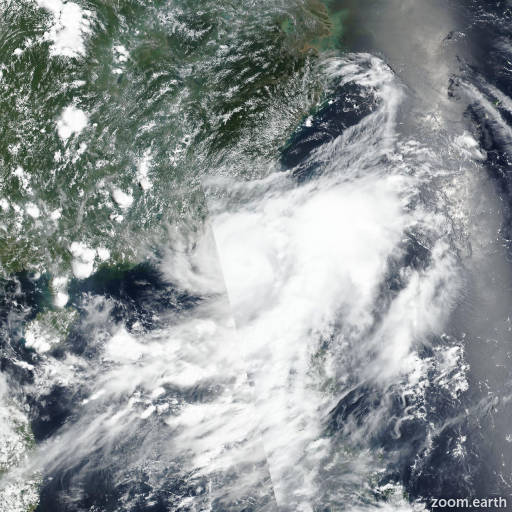
Live tracking map, satellite images and forecasts of Tropical Storm Danas 2025 (台風4号) southeast of Hong Kong. Current wind speed 100km/h. Max 155km/h.

Danas (Philippine name Bising) is located 432 km east-southeast of Hong Kong, and has tracked northeastward at 6 km/h (3 knots) over the past 6 hours. Maximum significant wave height is 5.2 meters (17 feet).

Danas is forecast to track northeastward over the next 2 days. Competing steering environment is causing the translation speed to oscillate around 5 km/h (3 knots), while the system approaches the Taiwan Strait.

Within the next 12 to 24 hours the near-equatorial ridge to the east will build and aid in defining the track of Danas. In around 3 days however, near-equatorial ridge will weaken and transit further south, while the subtropical ridge to the north builds and extends east-southeast, resulting in Danas sharply turning towards mainland China.

In terms of intensity, the system will likely rapidly intensify within the next 1 to 2 days, as indicated by multiple model consensus members, including specific rapid intensification (RI) aids (FRIA, ride, RIPA, DTOP and RICN), as long as the vortex remains over the warm strait waters.

In around 2 days, once Danas makes a westward turn and begins to interact with the terrain and eventually makes landfall, the forecast calls for rapid weakening.

Full dissipation over land is forecast in 4 days. Model guidance is in fair agreement with 102 km cross-track spread at 36 hours, while the system is transiting over the Taiwan Strait, expanding to 110 nautical miles, just north of the strait.

One immediate outlier is UKMET (EGRI) tracker indicating landfall over southern Taiwan in around 36 hours. Beyond 2 days, the uncertainty increases throughout the model guidance, therefore the landfall position is assessed with low confidence.

Intensity guidance is in fair agreement throughout the forecast as well, as witnessed by strong agreement in regard to the timeline of intensification and weakening, offset by some uncertainty associated with the peak intensity spread, which is currently assessed at 75 km/h (40 knots), excluding the RI aids.

The timeline of dissipation is in good agreement among the consensus members indicating intensity below warning criteria at or before 4 days, for all available guidance.

Overall good model guidance is offset by track uncertainty and its impact on intensification rate in relation to any potential land interaction, while the system is within or near the Taiwan Strait. Therefore overall JTWC intensity forecast is assessed with medium confidence.