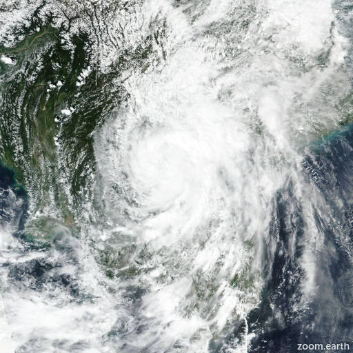
Tropical Storm Bualoi (Opong) 2025
Last Modified:

Live tracking map, satellite images and forecasts of Tropical Storm Bualoi 2025 (台風20号) near Palau. Current wind speed 75km/h. Max 130km/h.
Bualoi (Philippine name Opong) is located 289 km north-northwest of Koror, and has tracked westward at 13 km/h (7 knots) over the past 6 hours. Maximum significant wave height is 5.5 meters (18 feet).
Bualoi is expected to track generally west-northwestward throughout the forecast period under the continuous steering influence of subtropical ridging to the north.
Steady intensification should occur over the next 24 to 36 hours aided by low to moderate wind shear, favorable outflow aloft, and passage over very warm water. However, the upper-level low currently analyzed to the north of Bualoi will quickly translate westward, away from the system.
In its wake, the peripheral flow around a building upper-level ridge to the north will induce increasing wind shear over the system in 36 hours. This shear, combined with passage over land, are expected to weaken the system in 1.5 to 3 days. Thereafter, reintensification is likely in the South China Sea as the system passes over warm water and wind shear tapers.
Consensus and ensemble model track guidance is in good agreement over the next 3 days in terms of both direction and speed of motion. Spread increases after 3 days due to differing representations of the steering ridge orientation and intensity of the system. However, spread in the extended period is not as large as the previous cycle and nearly all models, except for NAVGEM and JGSM, show a track to the south and west of Hainan island in 4 to 5 days.
The current JTWC track forecast is consistent with the previous forecast and is situated slightly to the south of the multi-model consensus, within the primary grouping.
Model intensity forecasts are in broad agreement regarding the overall trend, including near-term intensification over the next 36 hours followed by a period of moderate weakening and ending with reintensification over the South China Sea.
The current intensity forecast lies near the mid point of the relatively narrow consensus model envelope.