Measure Distance

Measure Area

Click on the map to add points. Double‑click to finish.

Tap on the map to add points.

Major Hurricane Beryl 2024

Last Modified:
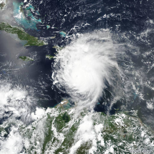
Hurricane Beryl

Live tracking map, satellite images and forecasts of Major Hurricane Beryl 2024 in the Caribbean Sea. Current wind speed 165mph.

Beryl is forecast to remain a powerful hurricane as it moves across the Caribbean Sea later this week. A Hurricane Warning is now in effect for Jamaica, where hurricane conditions are expected on Wednesday. A Tropical Storm Warning is also in effect for the south coast of Hispaniola.

Heavy rainfall and flash flooding are possible over portions of Jamaica on Wednesday.

Interests in the Cayman Islands, Belize, the Yucatán Peninsula, the remainder of the northwestern Caribbean, and the southwestern Gulf of Mexico should monitor the progress of Beryl. Additional watches and warnings will likely be required on Tuesday or Wednesday.

Data from a NOAA-P3 Hurricane Hunter aircraft tonight has been quite helpful in assessing Beryl's structure and intensity. Within the past hour, the aircraft measured a peak 700-mb flight-level wind of 180 mph (157 knots) in the northeastern quadrant. A typical 90% reduction translates to a maximum sustained wind of 160 mph (140 knots), which makes Beryl a potentially catastrophic Category 5 hurricane. This is the earliest Category 5 hurricane observed in the Atlantic basin on record, and only the second Category 5 hurricane to occur in July after Hurricane Emily in 2005.

Beryl continues to move quickly to the west-northwest, even a bit faster than earlier, estimated from plane fixes to be 290/19 knots. A well-established subtropical ridge oriented ESE-to-WNW of Beryl is expected to continue to steer the small but potent hurricane quickly west-northwestward into the central Caribbean over the next several days. After 48 hours, the strongest ridging becomes positioned more NW of Beryl, and the storm could turn a bit more westward and gradually slow down when it reaches the northwestern Caribbean. The guidance this cycle has nudged a bit further north this cycle, and thus the NHC forecast track has also been shifted in that direction, roughly between the reliable HCCA and TVCN consensus aids. After 72 hours, model track spread increases quite markedly, especially after Beryl emerges into the Gulf of Mexico, and forecast confidence in the track at the end of the forecast is rather low.

While I cannot rule out a bit more intensification in the short-term, dropsonde pressure observations between fixes in Beryl's eye have remained steady at 938 mb. It is also possible another eyewall replacement cycle (ERC) could begin like we saw last night, with UW-CIMSS MPERC model giving another ERC a 50-75% probability based on the last few microwave passes. With that said, after the next 24 hours, both the GFS and ECMWF remain insistent that significant mid-level westerly shear (above 30 knots) will begin to undercut Beryl's outflow layer. The HAFS-A/B regional-hurricane models, which did a good job predicting Beryl's peak intensity today (July 1), are also insistent this shear will start to disrupt the hurricane after the next 24 hours. There is evidence of this less favorable upper-level pattern on GOES-16 water vapor imagery upwind of Beryl's track, and thus a faster rate of weakening is forecasted from 36-72 hours. There remains much uncertainty of what Beryl's structure or intensity will be as it approaches or crosses the Yucatán, but the current GFS and ECMWF upper-level pattern in the Gulf of Mexico does not look especially favorable for restrengthening at the end of the forecast period.