Tropical Storm Mario 2025
Last Modified:

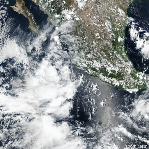
Live tracking map, satellite images and forecasts of Tropical Storm Mario 2025 near Mexico in the eastern Pacific Ocean. Current wind speed 40mph. Max 60mph.
Overnight and this morning (14 September), convection has increased in both coverage and organization with the remnants of Mario, which is now just east-southeast of Socorro Island. Earlier scatterometer data from a Metop-B pass at 04:28 UTC indicated that a well-defined center had reformed with a peak wind retrieval of 30 mph (27 knots). Given the improvement of the system's structure on satellite imagery since that time, it appears that Mario is now on its second life as a tropical cyclone. There was some question as to if this system was fully Mario, or some combination with another disturbance it is interacting with embedded in the monsoon trough to the south. However, there appears to be enough continuity between the prior circulation we were tracking near the coast of Mexico on Friday and the reformation of this new center to indicate this system is the same entity. The initial intensity this advisory is being set to 40 mph (35 knots), in good agreement with the 12 UTC TAFB Dvorak fix of T2.5/35 knots, a DPRINT estimate of 40 mph (36 knots) at 13 UTC, and a recent pressure observation of 1005 mb at Socorro Island, which appears to be just to the northwest of the tropical storm.
Mario is estimated to be moving slowly to the west-northwest at 285/7 knots. This general motion should continue for the next several days as Mario is primarily steered by deep-layer ridging centered over Mexico. Beyond 48 hours, Mario will likely become a shallow tropical cyclone and bend more westward before it dissipates in 3–4 days. The NHC track forecast is in fairly good agreement with the guidance aids, and generally is close to the simple and corrected consensus aids.
Mario is in a favorable environment currently, with low shear under 10 mph (10 knots), warm sea-surface temperatures between 28–30°C, and plenty of mid-level moisture. These favorable conditions persist for about 36 hours, and intensification is shown in the forecast, not that far off the most recent HAFS-B forecast. Afterwards, Mario will cross a very sharp temperature gradient while vertical wind shear also increases out of the southwest. Thus, Mario will likely weaken quickly between 48–60 hours, losing its organized convection to become a shallow remnant low by 60 hours, and dissipating entirely in 3–4 days. The NHC intensity forecast is a bit on the high side of the overall guidance envelope, but is close to the peak intensity of the latest HFIP corrected consensus approach (HCCA).