Tropical Cyclone 04P 2020-2021

Last Modified:
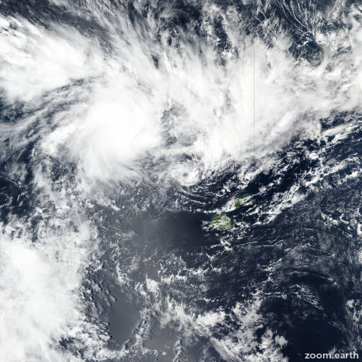
Satellite images, weather maps and tracks of Category 1 Tropical Cyclone 04P 2020-2021, December 9 - 12. Max wind speed 75km/h.

04P, located approximately 337 nautical miles west-northwest of Suva, Fiji, has tracked westward at 14 knots (25 km/h) over the past 6 hours.

Infrared satellite imagery shows disorganized, flaring convection obscuring a low level circulation center (LLCC). The initial position is placed with fair confidence based on the position of the LLCC in the infrared imagery loop as well as extrapolation through convective banding features present in a 12/09:57 UTC AMSU color composite image.

The initial intensity is assessed at 35 knots (65 km/h) due to the presence of 35 knot winds along the southeastern periphery of the system in data from a 12/08:44 UTC ASCAT-A pass.

The system is tracking along the northern periphery of a subtropical ridge positioned to the south and through a favorable environment with low (10-15 knots) vertical wind shear, warm (28-29°C) sea surface temperatures and divergent outflow aloft.

Despite these favorable conditions, the system has weakened significantly over the past 12 hours as it entered the capture phase of a direct cyclone interaction (DCI) with 04P which is located 115 nautical miles north of the system center.

Over the next 12 hours, 04P will continue to weaken and dissipate over water as it enters and completes the merger phase of this DCI and becomes incorporated into 04P.

Numerical models are in fair agreement during this 12 hour forecast and thus lend fair confidence in the JTWC forecast track which is placed slightly equatorward of the JTWC multi-model consensus.

This is the final warning on this system by JTWC. The system will be closely monitored for signs of regeneration.

Maximum significant wave height at 12/12:00 UTC is 14 feet (4.3 meters).

Information provided by the Joint Typhoon Warning Center (JTWC).